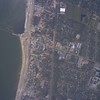
This is the NOAA satellite photo taken a day after Katrina, the area is
close to the foot of Courthouse Road and Highway 90, Gulfport, the old
Handsboro and Mississippi City historic district. If you scroll around
you will see the pier/jetty jutting out into the water, that is the old
"rock pile" as we used to call it. The corner of Cournthouse Road and Hwy
90 used to house the American Legion, and the old historic Courthouse
(that made it through Camille but is seen here as a square gray blank,
only the slab left), as well as several well known restaurants (also now
only slabs). Note that 90 is almost all under sand, I am told much of it
was washed out underneath. The railroad tracks can be clearly seen to the
right of the photo, maybe a quarter mile from the beach. All of that
light tan stuff, is what used to be the buildings on the square gray
slabs you see. You can see the surge line by following the light-tan
debris pile. That debris pile is impressive, bear in mind what you see in
that light tan stuff is 15 feet high, and every gray square you see is
only a concrete slab that used to be under a building. The railroad
tracks are what stopped the surge from moving furhter inland.
Apparently the only tree that can survive these storms is the Live Oak,
those are the only trees you see still standing. And the concrete slabs.
Dawn the morning after Camille in 1969, my dad said "Let's go down to The
Rock Pile and see how bad it was", the family having weathered Camille in
a house built in 1906 on Pass Road, a mile from the beach. Standing there
that morning in the breaking light of day, (and being the tender age of
13), and seeing what Camille had brought to us, I always thought, nothing
could be worse, nothing could do so much damage in such a short time, if
I can see all this catastrophic damage and live through it, well I can
handle anything. Well apprarently me and about 10,000 other people who
remember Camille were oh so wrong!
That light tan debris line in the photo link attached here, represents at
least 10 times the force of Camille.
Katrina had an eye 32 miles wide, with Cat 4 winds at landfall that
stretched 125 miles each side of the eye. Storm surge of 35 feet at the
eye, and 15 feet on the "outer" edges. Those outer edges reaching a
breadth of about 40 miles. She hit Hattiesburg at 110 mph sustained, and
that is 70 miles inland.
What you see in this photo, which represents about 3 miles of beach, is
what you will find from Pascagoula to Waveland, over 40 miles of
coastline. Sometimes only three blocks inland looks like this, sometimes
almost a mile inland.
This photo was Gulfport. Check the NOAA website for more photos.
Waveland, Bay St Louis, Pass Christian got hit worse. Biloxi got it bad
too, being swamped by both the Mississippi Sound and the back bay.
Six weeks later and it is still just overwhelming.
No comments:
Post a Comment